Sagas of East Surrey’s Groundwater
by Paul W Sowan
“In a wet summer, without any alteration in Church or State, a bourne rises in Birch Wood in Marden Park.”
Manning & Bray
Other chapters in this book deal with earlier myths and legends and beliefs concerning these bournes or ‘woe-waters.’ This contribution is solely concerned with our modern understanding of the chalk and the water held and moving within it below our district.
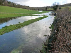
The Bourne beside Woldingham Road, February 2014
What are bourne flows?
Bournes, or intermittent springs and streams, are common features of chalk districts throughout southern England. In Surrey alone there are good examples at Farnham and Epsom as well as those in our own locality. There are several in Kent, including the Alkham, Cray, Little Stour, Pelham valley, North Stream and West Wickham bournes.
Despite fanciful treatment as ‘woe-waters’, the true nature and mechanism of bournes had been satisfactorily worked out almost two centuries ago. So well-understood is the Caterham–Croydon bourne, in fact, that Baldwin Latham was able to predict quite precisely all 15 flows from 1877 to 1912, from a careful study of rainfall records and well gaugings. No bournes flowed that he had not predicted. Much of the essential primary research into such matters was conducted in the chalk lands of east Surrey, making an interesting local scientific detective story.
Bournes are an occasional surface manifestation of underground water movement and levels, and the purpose of this contribution is to explain something about the nature of the chalk, and the water contained within it.
H H French, amongst others, summarised the causes of bournes thus—
- The chalk contains a great deal of water
- The water in the chalk derives from rainfall
- After excessive rainfall the volume of water in the chalk increases, its level rises, and some of it overflows
- Bournes are a part of this overflow
The fluctuations in the water table, or level to which the chalk is saturated with water, can be quite considerable. The well at Bug Hill Farm, for example, is 125 feet deep. At times it is dry, but when the bourne is flowing the well overflows, demonstrating vertical fluctuation of water table of at least 125 feet.
20th century hydro-geological research has moved on to more urgent matters, such as contamination of ground water and public supplies by excessive use of agricultural fertilizers, sex hormone traces from contraceptive pills, industrial leakage of toxic chemicals such as chloro-hydrocarbons, replenishing depleted water stocks by artificial recharge and (under our major cities) coping with ground water levels rising to such an extent that the infrastructure such as underground railways is threatened.
Are there natural cave systems in the chalk?
Early explanations of bourne flows envisaged vast natural underground chambers connected to the outlets (springs) by passageways in the form of a siphon. Supposedly, the chamber would gradually fill up like the tank of an automatic flushing lavatory cistern, and periodically (and much more rapidly) empty via the siphon. How often this happened would depend on the rate at which the chamber was refilled from rainfall. Our area of east Surrey is underlain by a great thickness (up to 900 feet) of chalk. The North Downs constitute a well-known dry valley landscape – plenty of valleys, but usually no surface streams, although there seem to have been streams in them in the past as many of the valley floors contain undoubtedly water-transported gravels. It was probably possible for more permanent surface streams to flow in the past for one or both of two reasons. In times of much higher rainfall, the chalk may have been completely saturated with water up to the surface of the ground, and thus unable to absorb any more, so that rainfall escaped as runoff. During the Ice Age in east Surrey, we enjoyed periglacial ‘permafrost’ conditions (the ice-sheets themselves ended to the north of London), rendering the frozen ground impermeable.
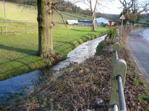
The Bourne beside Woldingham Road, February 2014
Only occasionally do temporary streams break out and flow, most famously in the Caterham valley, although a lesser-known Coulsdon bourne has also been noted, and another at Merstham.
Chalk is amongst the softest and most porous of the English limestones. It is interesting to compare it with the harder and denser Jurassic limestones of the Cotswolds, and to the even less porous Carboniferous limestone of the Pennines. Only the Carboniferous limestone, both in England and in Wales, is known to contain significant and extensive explorable caves and pothole systems, in which it is possible to go underground with the water and see exactly where it goes and what it does. The water is guided downwards through joints and cracks in the rock and, containing dissolved atmospheric carbon dioxide, gradually widens them by chemical solution. Sizeable caves develop presumably as a result of the superior mechanical strength of the rock, which prevents ceiling collapse.
Natural solution-caves in the chalk, in contrast, are rare. Some small ones, which can be explored by those happy to wriggle through small holes underground, are known in the cliffs at Beachy Head, some way above the beach, where marine erosion has exposed them. These are genuine groundwater solution caves, now accessible as a result of the cliff receding as the sea has undercut its base; they are quite distinct from the much more common wave-eroded caves at beach level. The largest recorded natural chalk cave in Britain was discovered, at a depth of 120 feet underground, during the construction of the waterworks at Strood (Kent). This chamber is ‘over 17 feet high, of considerable width and length, and from this … [there is] … a natural adit through which a person can walk for about 60 feet.’ William Coles-Finch(1908), the resident engineer, published plans, sections, and several photographs taken inside this remarkable cavity.
The nearest we have to known natural cave systems in the chalk under Surrey are in the Mole valley, where in very dry years the river disappears down potholes in its bed near Mickleham, re-emerging as springs near Leatherhead further downstream. Up in the hills to the east, in the Nower Wood Nature Reserve at Headley, you can (in very wet weather) see a small surface stream swallowed-up as it plunges down a tiny chalk ‘pothole’, a vertical-sided fissure in the chalk too narrow for even the most determined caver to descend!
Porosity and permeability of the chalk
The evidence is, therefore, that our bourne flows are not conducted underground through natural caves, in which all the water on the move would be concentrated in a small number of distinct tunnels. The chalk is not strong enough to allow their formation. Unlike the Jurassic and Carboniferous limestones, the chalk is an extremely porous rock. It contains up to 40% empty space, containing either air or water depending on circumstances. A lump of dry chalk will absorb a surprising amount of water, like a sponge. A favourite demonstration used to be done in which the contents of a two-and-a-half-gallon watering-can were poured into a foot cube of chalk … all of the water disappearing into the solid rock. There is, therefore, a very large quantity of water stored in the chalk under Caterham and area, but this pore water is far from easy to extract. If you stand the now-saturated cube of chalk under cover, you will not see any water draining out of it, although on a warm dry day it will very slowly lose water by evaporation from the surface. The force of capillary attraction hinders the movement of pore water through the mass. This water is effectively static, and has little direct bearing on bourne flows or water supply. Even the application of considerable hydrostatic pressure to one face of the cube would only squeeze a little water out rather slowly.
What really holds the ‘movable’ and recoverable water in the chalk is the extensive network of mostly tiny cracks and joints throughout the mass. To visualise the scale, stand on the beach at Newhaven or in a chalk pit and study the chalk cliff with care. Downing, Price and Jones (1993) estimate the ‘fracture porosity’ of the chalk at about 1% of its volume (as against 30 – 40% for the ‘matrix porosity.’)
Only one or two per cent of the water in the chalk is readily able to flow underground to wells, or emerge from springs as bourneflows.
Below the water table, both the pores and the cracks and joints are filled with water, above it only the pores in the chalk are so filled.
Chalk is not all the same throughout
A further important consideration is that the mass of the chalk is not a homogeneous network of evenly distributed open joints and micro-cracks. It was discovered in the 19th century that selecting a site for a successful deep well requires a considerable degree of geological understanding (and, indeed, luck!) A well sunk at one spot would have a disappointing yield, whilst another one nearby could be far more generous. Indeed, the knowledge and understanding required for successful well location is largely derived from experience with previous ventures.
More or less continuous layers of flint, and marl seams, can restrict or prevent water flow in certain directions. Fault-planes may allow flow through otherwise impermeable beds including especially the marly lowest beds of the chalk (this may explain certain chalk springs found along the base of the chalk escarpment). Anticlinal structures, where the chalk beds, arched upwards, are under tension and all the cracks are opened up fractionally, are favourable places for wells. SynclinalStructures– however – are not, as the chalk is compressed and all the joints closed-up. As so many of our deep public supply wells were sunk before all of this was fully understood, it was very common for the well-sinkers to drive adit sideways from them to intersect more fissures and increase the yield. Whitaker indicates that the St Lawrence’s Hospital and Reedham Asylum wells both had audit systems to tap additional water, and that the Caterham Waterworks’ three wells are all interconnected by adits at depth.
Joseph Lucas, in 1874, proposed an ingenious scheme of ‘horizontal wells’ up to 14 miles long, running east-west under the North Downs, to extract water for London. Although this was never put into practice, his text remains an important and fascinating source of local information about wells.
Rainfall distribution
Rainfall is of course greater in the winter months. It is also significantly greater on the higher parts of the North Downs than it is further down the dip slope towards Croydon. During the years 1878-87 (for example) there was an average annual rainfall of 34 inches high up on the Downs, but only 24 inches nearer to Croydon. Water levels in wells higher up in the hills rise more quickly than those further north. These factors probably explain why a bourne stream may break out in the Caterham valley, but disappear underground again before it reaches the culvert at Purley. On a much greater scale, in very hot summers the river Mole does the same sort of thing, and in very wet winters it floods.
The fate of rainwater
The average annual rainfall for Surrey is about 24 inches, or 2400 tons per acre per year. Up to 10 inches of this actually soaks into the ground. What becomes of rain once it has fallen depends on circumstances. A certain proportion soaks into the ground, gradually trickling down the cracks and joints until it reaches and augments the saturated zone below the local water table. That fraction is of interest in connection with bournes and water supplies. In steeply-sloping ground, or ground composed of more or less impermeable rock, the water escapes by ‘runoff’ via temporary or permanent streams. In an area such as Caterham, house roofs, road services and street gutters and drains have the same effect. In warm weather, some of the rainwater escapes back into the atmosphere by simple evaporation, whilst quite a lot more, in vegetated areas, is absorbed by the roots of plants and trees and is returned to the air by transpiration.
Bourne water and the Godstone quarries
The stratum of rock lying below the chalk, and outcropping at the foot of the escarpment from Godstone through Bletchingley Merstham and beyond, is the Upper Greensand, a bed which has been extensively exploited by underground quarrying (for building) and mining (for domestic hearthstone for whitening natural stone surfaces). Like the chalk above it, the Upper Greensand (a very porous largely siliceous rock) contains a considerable quantity of water, the levels of which have been accessible to observation as a result of the tunnelling. Authorities have differed on whether or not this Upper Greensand water can be regarded as in communication with, and an extension of, that in the chalk. Whilst the lowest, marly, beds in the chalk are of low porosity and in bulk impermeable, as we have seen, it is the presence of vertical joints rather than the nature of the rock itself that makes useful water storage and flow possible.
Local folklore has long associated the floodwater (often called the bournewater) in the underground building-stone quarries and hearthstone mines in the Upper Greensand at Godstone with bourne flows. Indeed, the underground quarries have been thought of by some as the great chamber which, when full, supposedly emptied itself through a siphon. It had not occurred to those who took this view that (unlike a siphon emptying a tank) the Godstone quarries fill and empty equally slowly.
A pamphlet reprinted from The Croydon Chronicle in 1861 tells us that at Sir William Clayton’s quarries, ‘worked by Messrs. Stedhall’ … —
“Access to the quarry is obtained, and lights can be procured at the principal entrance, which is through an arch seven feet high, and 10 or 12 feet wide, having a single line of tramway rails. The road descends inwards very gradually. From this roadway or gallery many branches diverge, ending in ‘rooms’, where the stone is dug.
The principal gallery wherein the Bourne water is now rising, extends about 350 yards inwards from the entrance, but now the water has risen to within 150 yards of the entrance, filling and rendering at present useless, the lower 200 yards of gallery with its diverging branches and rooms. The perpendicular depth of this water is guessed by the quarrymen at about 60 feet.
One day in December last, the Surrey Stag Hounds ran a deer into the neighbourhood of the quarry, when he entered the cavern, disappeared, and was no doubt drowned among the arches. Two hounds were sent in after him, but they returned without any sign of having reached the object of their search.”
This quarry entrance location is now buried below the western carriageway of the A22on Godstone Hill. The remains of the lost beast appear to have been removed long since, or possibly are hidden beneath or behind a roof-fall.
The principal origin of the water can still be seen in the form of one or two underground springs near the iron tramways in the main passages. These springs are usually flowing at least slightly throughout the year, which raises the question of where the water goes. It cannot and does not escape southward, as it is held up by the Gault clay underlying the quarry floor. The water almost certainly escapes to the north, through joints communicating from the Upper Greensand to the lower beds of the chalk under Caterham. Indeed, several chalk wells (Caterham Model Dairy, Caterham Waterworks, Purley Waterworks) penetrate the Upper Greensand(and some of them even the Lower Greensand as well) and so now allow an escape route.
For many years (1843-76) a quarryman named Hills was in the habit of marking the highest flood water level each year on the walls in the quarries under Godstone Hill. Baldwin Latham collected all these measurements and related them to mean sea level and to bourne flows. His conclusion was that there is no direct and simple correlation of water-levels in Godstone quarries with bourne flows. For example, in two years when the water was particularly high (460.09 feet in 1849, and 462.75 feet in 1854) there was no bourne flow, but in 1876 when the water in the quarries stood at only 443.12 feet, a bourne flowed. As Latham observed, the fact that quarrying (which is thought to have started underground here as recently as the 17th century) was progressively enlarging the volume of the worked-out chambers and tunnels (right through to the early years of the 20thcentury), a simple relationship was not to be expected. Bourne flowed before quarrying started, and have continued since it ceased.
Hills’ water-level marks cannot now be found on the underground quarry walls, so presumably they are in an area now inaccessible beneath or behind roof-falls.
The underground quarries at Merstham
There is another extensive series of underground tunnels and chambers in the Upper Greensand some miles further west along the outcrop from Godstone. About 10 miles of these, still accessible, have been accurately surveyed by members of the Wealden Cave and Mine Society. These underground voids are certainly much older than the Godstone quarries, and probably include the two Limpsfield manor quarries mentioned in Domesday Book (1086). Limpsfield manor at that time held land in what was to become the southern part of Chaldon parish, along Spring Bottom Lane. Chaldon lost this land to Blechingley as a result of local government reorganisation in 1933.
The quarry gallery networks run right through into the next parish, Merstham, where the most recent quarrying and mining was all but finished by the 1820s. It is only in the Quarry Dean area that ground water has been troublesome to the underground workers. In Chaldon, they simply stopped quarrying northwards when they encountered waterlogged rock.
Messrs Jolliffe and Banks, an important early civil engineering contracting firm with (amongst other monuments) a number of London’s bridges to its credit, leased and attempted to develop the underground building-stone quarries at Quarry Dean early in the 19thcentury. Its attempts to follow and exploit the ‘Reigate stone’ northwards, down the dip of the stratum, were at first frustrated by high ground water levels. Amongst other capital-intensive developments (the horse-drawn Croydon, Merstham and Godstone Iron Railway, a stationary steam engine, and an inclined plane) it sought to make a drainage adit or sough from below the quarry, under the Rockshaw Road ridge, to convey the unwanted water to lower ground to the south. This sough, made between 1807 and 1809, was initially successful, and allowed quarrying to extend into formerly water-logged ground. In fact it was so successful that it diverted water that hitherto had supplied the western of Merstham’s two watermills, which promptly stopped working. During the next few years the drainage tunnel fell in and blocked the water egress, was cleared (or cleared itself), and blocked itself up again. It has remained blocked since the 1820s, and parts of the quarries at Quarry Field and Quarry Dean are now only accessible with diving equipment. The location of the blocked outfall, still leaking water slowly, can be seen near the north end of the footbridge carrying the path from Malmstone Avenue over the M25 and on to Rockshaw Road.
The water in these two small quarry systems does not appear to be directly linked, as the levels fluctuate ‘out of synch’. This being the case, the lack of a direct relationship between the Godstone quarry water levels and bourne flows is hardly surprising. It is a tortuous route through an enormous maze of tiny cracks, so water at a higher level in one location takes some considerable time to percolate through to another.
The Betchworth and Brockham hearthstone mines
As recently as the 1960s I was told by a former hearthstone miner that they had trouble with ‘the bourne water’ in the mines at Betchworth. Some 20 years earlier ‘bourne water’ was reported at the bottom of the shaft at the abandoned hearthstone mine at Brockham. The fame of the Caterham bourne had certainly reached almost to Dorking!
The effect of the Oxted railway tunnel
The prospect of a railway tunnel through the Downs to Oxted was of concern to watermill owners on the river Wandle, and to owners of wells in the Caterham valley area, from as early as the proposed South Eastern Railway main line on that alignment, in 1836-38. Some tunnelling was done at Riddlesdown, although not on the line of the current Riddlesdown tunnel, between March 1837 and September 1838, when work was abandoned. As far as I am aware, no work was done for the SER in the MardenPark area. The company was required by Parliament to share the London and Brighton Railway Company’s line as far as Redhill, before sending its trains eastwards toward Dover via South Nutfieldand South Godstone.
The concern was that such a tunnel would drain very large quantities of water southwards out of the hills, whereas it had always previously flowed northwards to Croydon. Baldwin Latham commenced his career as engineer and surveyor for Croydon in 1866, just as the Surrey and Sussex Junction Railway was commencing work on what became the Oxted line, with new tunnels at Riddlesdown and Marden Park. The SSJR works were abandoned early in 1867, so our water remained safe, but 13 years later the line was revived, as the Croydon, Oxted and East Grinstead Railway, and both tunnels completed between 1880 and 1883. Latham was ready and waiting to assess the damage to the water reserves, and in fact arranged to gauge the flow southwards from the earliest possible moment – in 1881 – when the tunnel was sufficiently far ahead to be able to conduct water southwards. He estimated that making the tunnel had effectively transferred two square miles of the river Wandle’s catchment area to that of the river Eden.
The Oxted line runs downhill all the way from the line summit near Woldingham Station, through the Oxted tunnel, thus acting as an approximately horizontal well. It continues to drain water out of the North Downs to this day.
The Merstham railway tunnels
The two railway tunnels at Merstham, on the main Brighton line, have much less effect on the water reserves in the chalk. In both cases, the line summit is within the tunnel. The western and earlier tunnel (made 1838-41) is at a lower elevation than the Quarry Line tunnel of 1897-1900, and is therefore more directly responsible for water loss from the Downs. The southern part of the tunnel has a culvert southwards to the Weald, whereas the northern end drains back to the chalk near Coulsdon South Station. Thus these long tunnels (both over a mile) have far less effect than that at Oxted. The southern culvert is confused by the usually very reliable Latham with the Merstham quarries’ drainage adit of 1807-09. What he says about this should be disregarded.
Predicting bourne flows
The most important factor in predicting flows is the winter rainfall record. Summer rainfall is generally lighter, and less water is absorbed into the ground because warmer weather leads to greater evaporation, and more foliage on plants and trees means more transpiration.
Bournes in the future
The Caterham–Croydon Bourne is, of course, a less obvious feature of modern life than it was, if only because its course is now largely hidden by confinement within concrete channels and underground culverts. A number of factors have a bearing on the frequency of bournes, including especially the much greater run-off and loss of water to the sewerage system resulting from covering the countryside in roads, asphalted parking areas, and buildings. Acting in the opposite sense, a reduced number of trees lessens the losses of rainfall returned to the atmosphere by transpiration. Increased abstraction of water for profligate car-washing, lawn- sprinkling, and use of dishwashers and washing-machines will have its effect. Long- term trends in rainfall and global warming will have their own influence. If in due course England finds itself a drier and hotter country with a climate such as southern France or Italy currently enjoy, bournes may become rarer or cease altogether.
REFERENCES
ANON, (1861). The Bourne. Pamphlet reprinted from the Croydon Chronicle.
COLES-FINCH, William, (1908) Water: its origin and use. London: Alston Rivers Ltd: xxi+ 483 pages.
COOLING, Christine M (1968). Records of wells in the area of New Series One-inch (Geological) Reigate (286) and Sevenoaks (287) sheets. Institute of Geological Sciences: iv+ 94pp.
DOWNING, R A, PRICE, M and JONES, G P (1993). The hydrogeology of the Chalk of north-west Europe. Oxford: Clarendon Press: ix+ 300 pages.
FRENCH, H H (1883), A paper on bournes, 19 October 1883. Sutton Scientific Society: 31pp.
LATHAM, Baldwin (1876), in discussion of Joseph Lucas’s paper q.v., pages 126-134.
LATHAM, Baldwin (1904), Croydon Bourne flows. Paper read before the Croydon Natural History and Scientific Society on the 17 May, 1904. Privately printed: 44pp+ folded sections.
LUCAS, Joseph (1874), Horizontal wells. A new application of geological principles to effect the solution of the problem of supplying London with pure water. London: Edward Stanford: viii+ 86 + (2) pages + three folded plates.
LUCAS, Joseph (1876), The chalk water system. Minutes of Proceedings of the Institution of Civil Engineers 47, 70-167 [including discussion]
MILL, Hugh Robert (1936), Average annual rainfall. Croydon Natural History and Scientific Society Regional Survey Atlas of Croydon and District (22) [and accompanying text by C.C.Fagg]
WHITAKER, William (1912), The water supply of Surrey from underground sources. Memoir Geological Survey of Great Britain: v + 352pp+ folded rainfall map.